
NOAA Science Seminar Series
The NOAA Science Seminar Series began in 2004 and is a voluntary effort by over 70 NOAA seminar coordinators to integrate and distribute a list of NOAA-hosted, publicly accessible science seminars. In 2020 we shared listings for over 500 seminars!
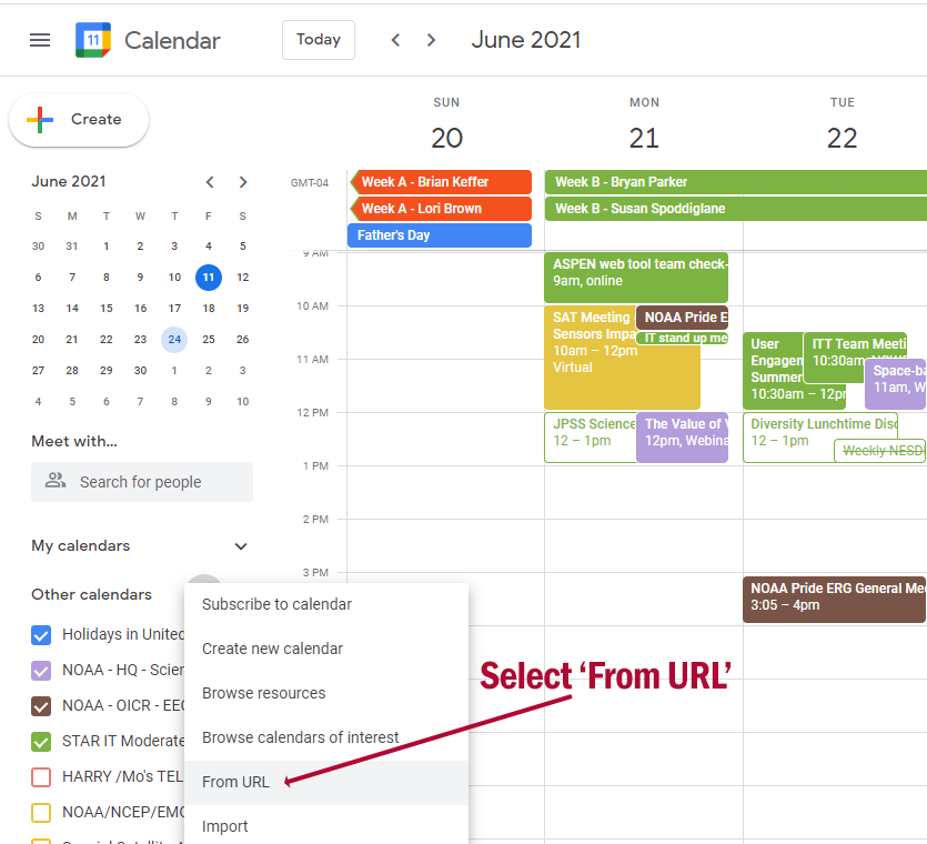
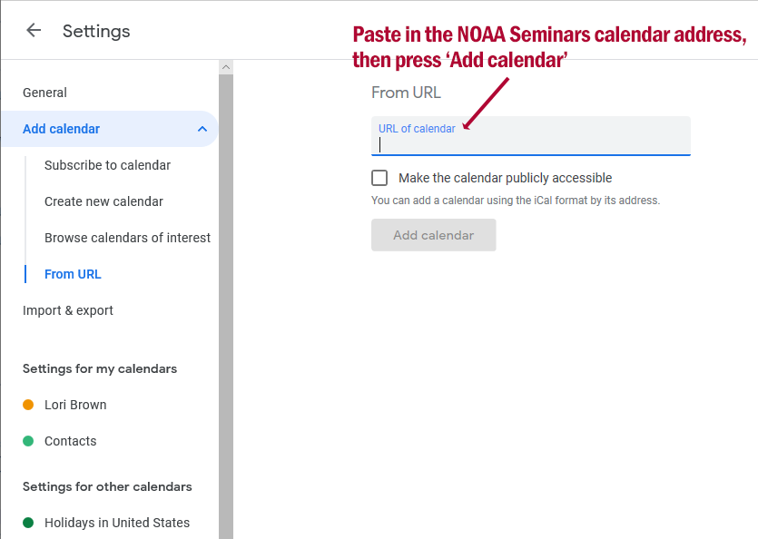
How to SubscribeSend an email with the word 'subscribe' or 'unsubscribe' in the subject or body to [email protected], or: Visit: https://list.woc.noaa.gov/listinfo/onenoaascienceseminars and submit your e-mail address to the subscription form. If you have difficulty with subscribing or unsubscribing from the list, please contact us at [email protected] for assistance. Once you have subscribed, you will receive a weekly e-mail every Monday morning that summarizes upcoming seminars. Add the NOAA Science Seminar Series to your Google CalendarIf you would like to add the NOAA Science Seminar Series to your own Google calendar view: 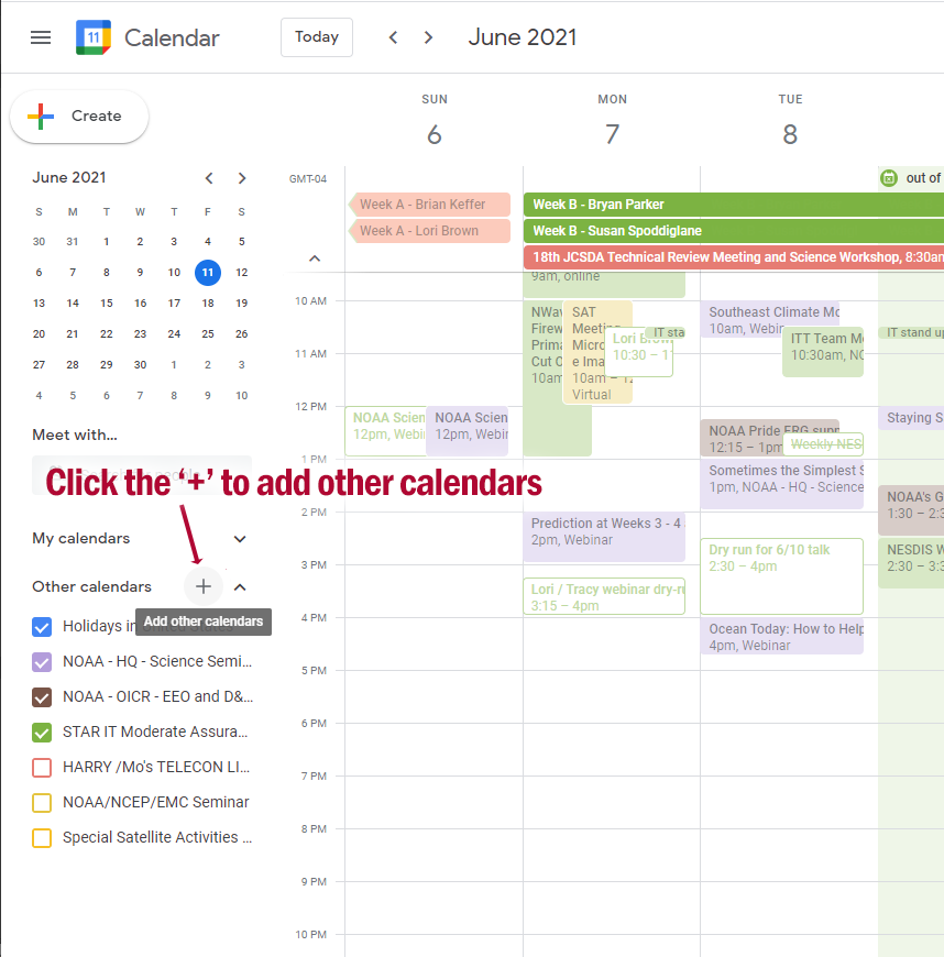
Add the seminar calendar, screen 1
|
| Title: | Streamflow Forecasting using Physical-Aware AI/DL Models and Improving the Precipitation Forecasts at the Subseasonal-to-Seasonal Scale in Support of Adaptive Reservoir Operation |
|---|---|
| Presenter(s): | Dr. Tiantian Yang, Associate Professor, School for Environment and Sustainability, University of Michigan |
| Date & Time: | 12 November 2026
11:00 am - 12:00 pm ET |
| Location: | hybrid / webinar |
| Description: |
Title: Streamflow Forecasting using Physical-Aware AI/DL Models and Improving the Precipitation Forecasts at the Subseasonal-to-Seasonal Scale in Support of Adaptive Reservoir Operation Presenter(s): Dr. Tiantian Yang, Associate Professor, School for Environment and Sustainability, University of Michigan Sponsor(s): CIGLR and NOAA GLERL Seminar Contact(s): Margaret Throckmorton, [email protected] Remote Access: Please register at: Accessibility: Closed captions are available at GoToWebinar during the talk. Abstract: Reservoirs and lakes are fundamental and multi-functional water infrastructures that collect, store, and deliver surface freshwater for a multitude of uses, including flood and fire control, recreation, wildlife habitat, residential, industrial, agricultural practices, irrigation, hydro-electric power generation, drought mitigation, and more. In recent years, more frequent and severe abrupt weather extremes, natural hazards, aging infrastructure, and increased water demands due to population growth have placed another significant barrier preventing the effective, sustainable, and adaptive operation of the existing reservoir and lake systems. Therefore, new technologies and innovations are critically needed to improve the existing reservoir and lake operation and management of built water systems in our nation. In support of adaptive reservoir operation Dr. Tiantian Yang will present his current research on enhancing streamflow prediction at subseasonal-to-seasonal timescales by improving precipitation forecasts and hydrologic simulations through the integration of physical hydrologic models and physically-aware artificial intelligence and deep learning (AI/DL) tools. These hybrid models aim to retain the interpretability and physical consistency of traditional models while leveraging the pattern recognition and scalability of AI/DL. Recordings: See this link: https://ciglr.seas.umich.edu/event/10082026-tiantian-yang/ Subscribe to the NOAA Science Seminar Series weekly email: |
| Add seminar: | Add to Google calendar |
| Title: | Hybrid Aviation Weather Climate Interface - HAWCI |
|---|---|
| Presenter(s): | Drake Valencia, NOAA Cooperative Science Center for Earth System Sciences and Remote Sensing Technologies II (CESSRST-II) |
| Date & Time: | 12 November 2026
12:30 pm - 1:30 pm ET |
| Location: | Webinar |
| Description: |
Title: Hybrid Aviation Weather Climate Interface - HAWCI Presenter: Drake Valencia, Master’s Graduate Fellow, NOAA Office of Education, Educational Partnership Program with Minority Serving Institutions (EPP/MSI), NOAA Cooperative Science Center for Earth System Science and Remote Sensing Technologies II (CESSRST II), Cohort 3, at San Diego State University, San Diego, CA Sponsor: NOAA EPP Cooperative Science Centers Seminar Contact(s): [email protected] and [email protected] Or dial: (US)+1 650-535-0912 PIN: 957827 733# More phone numbers: https://tel.meet/cpt-znyu-stw?pin=6837475286982 Accessibility: Google Meet closed captioning available. Abstract: Crosswind, ceiling, and visibility constrain Southern California aviation, but forecast guidance covers one airfield and one variable at a time, leaving no quantified regional picture. METAR observations from 53 ASOS and AWOS stations (2006 to 2025, 10,403,137records) were paired with FAA NASR runway headings to resolve crosswind trigonometrically, then reduced to lagged conditional probabilities for all ordered station pairs, stratified by wind direction, season, month, and time of day. The domain packs dozens of civilian and military airfields across varied terrain. Calm wind, not wind direction, dominates inland low-visibility conditions, where rates run three to four times the directional-wind rate. Crosswind co-occurrence is strongest among coastal fields, while ceiling and visibility co-occurrence tracks shared elevation and terrain rather than distance. The results presented are from the NOAA EPP CSC NERTO graduate internship project conducted under the mentorship of Ivory Small, National Weather Service, San Diego Weather Forecast Office. This NERTO experience aligns with the NOAA Cooperative Science Center in CESSRST-II, supporting the Center's goal of conducting NOAA mission-aligned collaborative research to understand and predict changes in weather and atmosphere. This project, titled HAWCI-Hybrid Aviation Weather Climate Interface, addressed the research question: how often do Southern California airfields exceed operational crosswind, ceiling, and visibility thresholds, and which other airfields follow, and after how long? The work provides value to the scientific community and program stakeholders by converting two decades of routine observations into a quantified regional climatology and a standalone operational tool. Through this internship, the student deepened their understanding of NOAA mission areas and gained enhanced skills in large-scale data pipeline development, Python programming, spatial statistics, and operational software delivery.
Send an e-mail to [email protected]with the word 'subscribe' in the subject or body. Visit the NOAA Science Seminar Series website for more information. We welcome your suggestions and ideas! |
| Add seminar: | Add to Google calendar |
| Title: | From Satellites to Cells: a comparison of methods to measure phytoplankton and Harmful Algal Blooms in Charleston Harbor |
|---|---|
| Presenter(s): | Emilia Lepe, NOAA Cooperative Science Center for Earth System Sciences and Remote Sensing Technologies II (CESSRST-II) |
| Date & Time: | 12 November 2026
1:30 pm - 2:15 pm ET |
| Location: | TBD |
| Description: |
Title: From Satellites to Cells: a comparison of methods to measure phytoplankton and Harmful Algal Blooms in Charleston Harbor Presenter: Emilia Lepe, Master’s Graduate Fellow, NOAA Office of Education, Educational Partnership Program with Minority Serving Institutions (EPP/MSI), NOAA Cooperative Science Center for Earth System Science and Remote Sensing Technologies II (CESSRST II), Cohort 3, at Brooklyn College, City University of New York Sponsor: NOAA EPP Cooperative Science Centers Seminar Contact(s): [email protected] and [email protected] Or dial: (US)+1 316-789-6405 PIN: 439568 290# More phone numbers: https://tel.meet/udt-cpam-jyi?pin=5127991265214 Accessibility: Google Meet closed captioning available. Abstract: Charleston Harbor, South Carolina, isa tidally flushed estuary where phytoplankton respond to both tidal flushing and nutrient inputs from land. Harmful algal blooms (HABs) can degrade water quality, so monitoring must cover both space and time. Point sampling cannot easily track blooms across the harbor, and satellite ocean color is limited in turbid, optically complex water where colored dissolved organic matter and sediment can mask chlorophyll-a signals. This 12-week internship at the Hollings Marine Laboratory provided training in methods that characterize phytoplankton across scales: scanning electron microscopy, flow imaging with a newly installed FlowCam 8100, high-performance liquid chromatography (HPLC)pigment analysis, smartphone-based reflectance measurements with the HydroColorapp, and Sentinel-2 satellite imagery processed with ACOLITE atmospheric correction and the chl_oc2 algorithm. On June 23, 2026, the chlorophyll-a map showed lower values around the Plum Island Wastewater Treatment Plant diffusers than in the surrounding harbor. This pattern may reflect reduced phytoplankton growth where the effluent carries fewer nutrients, or an optical artifact of rising bubbles and fresher water at the diffusers; a time series with optical correction and in-situ validation is needed to tell them apart. Electron microscopy showed that species-level identification depends on fine cell structure that no satellite pixel can resolve, illustrating the trade-off between spatial coverage and taxonomic resolution and why these methods are most useful in combination. The results presented are from the NOAA EPP CSC NERTO graduate internship project conducted under the mentorship of Steve Morton, NCCOS, Hollings Marine Laboratory. This NERTO experience aligns with the NOAA Cooperative Science Center in CESSRST-II, supporting the Center’s goal of conducting NOAA mission-aligned collaborative research to understand and predict changes in weather and atmosphere, land and water, oceans and coasts. Through this internship, the student deepened their understanding of NOAA mission areas and gained enhanced skills in HPLC pigment analysis, phytoplankton identification, scanning electron microscopy (SEM), FlowCam imaging, satellite image processing, and science communication.
Send an e-mail to [email protected]with the word 'subscribe' in the subject or body. Visit the NOAA Science Seminar Series website for more information. We welcome your suggestions and ideas! |
| Add seminar: | Add to Google calendar |
| Title: | Environmental nucleic acids have expiration dates: multi-omic monitoring and when to trust It |
|---|---|
| Presenter(s): | Aden Ip, University of Washington |
| Date & Time: | 12 November 2026
2:00 pm - 2:50 pm ET |
| Location: | online |
| Description: |
Title: Environmental nucleic acids have expiration dates: multi-omic monitoring and when to trust It Northwest Fisheries Science Center's Monster Seminar Jam Presenter(s): Aden Ip, PhD, University of Washington Sponsor(s): NOAA Fisheries Northwest Fisheries Science Center Seminar Contact(s): nwfsc.monsterjam@noaa.gov Remote Access: Online: meet.google.com/wtc-ivfo-jzg Abstract: N/A Subscribe to the NOAA Science Seminar Series weekly email: |
| Add seminar: | Add to Google calendar |
| Title: | Integrating management-relevant research into the planning of dredge operations in Southeast Florida (RECORDED) |
|---|---|
| Presenter(s): | Xaymara Serrano, NOAA NMFS |
| Date & Time: | 12 November 2026
4:00 pm - 5:00 pm ET |
| Location: | Webinar |
| Description: |
Title: Integrating management-relevant research into the planning of dredge operations in Southeast Florida Presenter(s): Xaymara Serrano, NOAA National Marine Fisheries Service, Southeast Regional Office, Habitat Conservation Division and Erin Winslow, NOAA NMFS, Office of Habitat Conservation, Habitat Protection Division Sponsor(s): NOAA Coral Reef Conservation Program Remote Access: https://meet.google.com/pgn-asvi-kgp Seminar Contact(s): Caroline Donovan, [email protected] Accessibility: Closed captioning available through Google Meet platform Abstract: Dredging operations and coastal development pose considerable threats to adjacent, already-stressed coral reef ecosystems. Fostering cross-line office collaboration within NOAA, alongside federal, state, academic, and NGO partners, has proven to be a valuable approach for delivering applied, management-relevant research. Over a decade of survey data shows urbanized reefs retain high conservation value, supporting millions of stony corals within 1.2 km of the Port Everglades channel, including ESA-listed staghorn corals (Acropora cervicornis). Comparative studies across Port Miami and Port Everglades helped establish rapid dive survey methods for sediment deposition and benthic stress indicators to aid real-time decision-making. Coupled with photogrammetry, water quality monitoring, and laboratory turbidity experiments, these findings directly inform ESA Section 7 and EFH consultations in Southeast Florida, refining protective thresholds and improving conservation outcomes. Recordings: Seminar recording will be available afterward, as requested. Subscribe to the NOAA Science Seminar Series weekly email: |
| Add seminar: | Add to Google calendar |
13 November 2026
| Title: | Integrating technology and imagery into evaluations of coral reef condition |
|---|---|
| Presenter(s): | Neidibel Martínez, NOAA Cooperative Science Center for Earth System Sciences and Remote Sensing Technologies II (CESSRST-II) |
| Date & Time: | 13 November 2026
1:00 pm - 2:00 pm ET |
| Location: | Webinar |
| Description: |
Title: Integrating technology and imagery into evaluations of coral reef condition Presenter: Neidibel Martínez, Doctoral Graduate Fellow, NOAA Office of Education, Educational Partnership Program with Minority Serving Institutions (EPP/MSI), NOAA Cooperative Science Center for Earth System Science and Remote Sensing Technologies II (CESSRST II), Cohort 3, at the University of Puerto Rico Mayaguez Campus, Mayaguez, PR Sponsor: NOAA EPP Cooperative Science Centers Seminar Contact(s): [email protected] and [email protected] Or dial: (US)+1 440-482-1466 PIN: 388111 016# More phone numbers: https://tel.meet/uoq-gcdw-toa?pin=6558698891650 Accessibility: Google Meet closed captioning available. Abstract: Coral reef structural complexity supports habitat and ecological function, so accurate measurement is essential for monitoring and restoration. In-water surveys face time, logistical, and safety constraints, creating a need for scalable approaches such as large-area imaging (LAI) and Structure-from-Motion (SfM) photogrammetry. NOAA needs consistent workflows to monitor restoration areas, integrate imagery from different platforms, and distinguish ecological change from methodological variability. Using the SfM section of NOAA’s Mission: Iconic Reefs LAI guidance as a reference, this NERTO project developed a reproducible framework for comparing diver- and ROV-based imagery while quantifying processing variability. The analysis used imagery from reef restoration sites, a relevant setting for fine-scale structural monitoring. We processed images in Agisoft Metashape using different alignment, depth-map quality, and filtering configurations. Reconstructions were screened using checkpoint RMSE, reprojection error, coverage, point density and confidence, completeness, noise, processing time, and file size. We compared leading products as standardized digital elevation models in R using a common region of interest and surface complexity ratio. Higher-detail reconstruction produced approximately four times more points and a larger file but changed surface complexity by only about 3%. Preliminary diver–ROV results showed broadly similar structural patterns, but the areas were not spatially paired and therefore cannot demonstrate platform agreement. These findings provide NOAA with a stronger QA/QC basis for selecting efficient processing settings and designing paired comparisons that support reproducible, scalable coral reef restoration monitoring. The results presented are from the NOAA EPP CSC NERTO graduate internship conducted under the mentorship of Dr. Shay Viehman at NOAA’s NCCOS Beaufort Laboratory, NC. This project supports the NOAA CESSRST-II mission of understanding and predicting environmental changes, particularly in oceans and coastal ecosystems. The project investigated how variations in SfM processing parameters and diver- versus ROV-based imagery influence the accuracy, consistency, and efficiency of coral reef structural measurements, with the goal of developing standardized workflows for reproducible coral reef restoration monitoring.
Send an e-mail to [email protected]with the word 'subscribe' in the subject or body. Visit the NOAA Science Seminar Series website for more information. We welcome your suggestions and ideas! |
| Add seminar: | Add to Google calendar |
16 November 2026
| Title: | NOAA’s Satellite Land Product Suite: From Observations to Applications |
|---|---|
| Presenter(s): | Dr. Peng Yu, Research Physical Scientist Lead, Satellite Land Product Development Team, NOAA/NESDIS |
| Date & Time: | 16 November 2026
12:00 pm - 1:00 pm ET |
| Location: | Webinar |
| Description: |
Title: NOAA’s Satellite Land Product Suite: From Observations to Applications Presenter(s): Dr. Peng Yu, Research Physical Scientist Lead, Satellite Land Product Development Team, NOAA/NESDIS Sponsor(s): NOAA/NESDIS Office of Low Earth Orbit (LEO) Observations Seminar Contact(s): Amy Leibrand ([email protected]) Remote Access: Abstract: NOAA’s satellite land surface products provide valuable environmental context for weather forecasting, hazard monitoring, and decision support. The NESDIS Satellite Land Product Development Team focuses on a targeted suite of products: Land Surface Temperature, Albedo/Bidirectional Reflectance Distribution Function (BRDF), Vegetation Index, Green Vegetation Fraction, Surface Reflectance, and Leaf Area Index. Together, these products characterize land surface conditions that shape exchanges of energy, moisture, and radiation between the land and atmosphere. This presentation will provide an overview of the product suite and its applications. Slides: Contact Amy Leibrand ([email protected]) Subscribe to the NOAA Science Seminar Series weekly email: Send an e-mail to [email protected] with the word 'subscribe' in the subject or body. Visit the NOAA Science Seminar Series website for more information. We welcome your suggestions and ideas! |
| Add seminar: | Add to Google calendar |
| Title: | The Community Earth System Model and the Future of Earth System Modeling |
|---|---|
| Presenter(s): | David Lawrence, CESM Chief Scientist, NCAR |
| Date & Time: | 16 November 2026
2:30 pm - 3:30 pm ET |
| Location: | Webinar |
| Description: |
Presenter(s): David Lawrence, CESM Chief Scientist, NCAR Sponsor(s): Earth System Science Interdisciplinary Center (ESSIC) Seminar Series Seminar Contact(s): John Xun Yang, [email protected] Remote Access: Webinar: https://go.umd.edu/essicseminarwebinars Zoom Meeting ID: 918 7733 3086 Abstract: The Community Earth System Model (CESM) and Earth system models in general are evolving in response to emerging scientific priorities, growing societal demands for actionable climate information, especially related to risks from changes in extreme events, and transformative changes in computing technologies. This presentation will provide an overview of recent CESM development activities emphasizing evolving Earth system capabilities, and new approaches for accelerating model development and deployment. Meeting the evolving needs from ESMs requires advances in both scientific realism and computational capability, including movement toward high-resolution (10–25 km) and ultra-high-resolution (km-scale) modeling configurations, more seamless prediction systems spanning subseasonal-to-seasonal (S2S), seasonal-to-decadal (S2D), and multidecadal climate projections, and exploiting AI through hybrid Machine Learning / Physics model versions and flexibly coupled emulators. The talk will discuss CESM progress in these realms and plans for the future. Accessibility / Slides: Closed captions available via Zoom Miss a seminar? All ESSIC seminars are posted on our YouTube channel within a week of the event: https://www.youtube.com/@ESSICUMD Subscribe to the NOAA Science Seminar weekly email: Send an email to [email protected] with the word 'subscribe' in the subject or body. Visit the One NOAA Science Seminar Series website for more information. |
| Add seminar: | Add to Google calendar |
| Title: | Empowering Youth to Conserve their Coastal Wetlands – Education, Communication, and Partnership in the Indo-Pacific |
|---|---|
| Presenter(s): | Mary Mar E. Jaleco of the John B. Lacson Foundation Maritime University, Matthew Vincent Tabilog of Mangrove Matters Philippines and Youth Engaged in Wetlands (YEW), and Phebe Fidge of the UN Decade on Ecosystem Restoration Youth Task Force |
| Date & Time: | 16 November 2026
10:00 pm - 11:00 pm ET |
| Location: | Webinar |
| Description: |
NOAA Science Seminar Series Title: Empowering Youth to Conserve their Coastal Wetlands – Education, Communication, and Partnership in the Indo-Pacific Presenter(s): Mary Mar E. Jaleco of the John B. Lacson Foundation Maritime University, Matthew Vincent Tabilog of Mangrove Matters Philippines and Youth Engaged in Wetlands (YEW), and Phebe Fidge of the UN Decade on Ecosystem Restoration Youth Task Force Sponsor(s): Open Communications for the Oceans (OCTO) with support from the NOAA National MPA Center Seminar Contact(s): Danielle Becker - [email protected] or Sarah Carr - [email protected]. Remote Access: Register at: https://us02web.zoom.us/webinar/register/WN_MDO2TFwlS1OXevh1Yf9rjA Abstract: Coastal mangrove and seagrass ecosystems are vital for shoreline protection and coastal livelihoods, yet many are degraded or threatened by human impacts. Engaging youth in conservation and restoration is essential, but barriers such as inadequate support, policy gaps, and unclear pathways for participation limit meaningful, sustained engagement. This webinar will explore how youth-led and youth-focused initiatives are advancing coastal wetlands conservation across local, regional, and global scales. Speakers will share experiences from immersive, place-based learning; grassroots youth organizing; and international policy engagement. After the presentations, there will be live Q&A to address questions from webinar participants about how they can empower inclusive and effective youth-centered approaches to coastal wetlands conservation and restoration in their own communities. Slides / Recordings / Other materials: A recording can be found after the meeting at the URL listed above. Accessibility: Captioning will be available in over 30 languages. Subscribe to the NOAA Science Seminar Series weekly email: Send an e-mail to [email protected] with the word 'subscribe' in the subject or body. Visit the NOAA Science Seminar Series website for more information. We welcome your suggestions and ideas! |
| Add seminar: | Add to Google calendar |
18 November 2026
| Title: | Developing tools to advance reproductive control in oysters |
|---|---|
| Presenter(s): | Lauren E. Vandepas; NWFSC Affiliate/University of Washington School of Aquatic and Fisheries Science; CICOES Fellow |
| Date & Time: | 18 November 2026
2:00 pm - 3:00 pm ET |
| Location: | Webinar |
| Description: |
Title: Developing tools to advance reproductive control in oysters NOAA Library Seminars Presenter(s): Lauren E. Vandepas; NWFSC Affiliate/University of Washington School of Aquatic and Fisheries Science; CICOES Fellow Sponsor(s): NOAA Omics and NOAA Library Seminar Contact(s): Nicole Miller ([email protected]) and Library Seminars Remote Access: https://vimeo.com/event/6312276 Accessibility: Captions are available during the live presentation and once uploaded to the NOAA Central Library YouTube Channel automatic captions are added. Sign language interpreting services and closed captioning are available, but need to be requested at least 5 days before the event. Abstract: Reproductively sterile oysters are important for aquaculture. Triploidy, the current method to achieve sterility in shellfish, can have adverse effects on survival. An alternative approach is the disruption of genes essential for gamete formation. To develop this approach in oysters, two challenges must be overcome: 1) characterization of genes underlying bivalve primordial germ cell (PGC) development, and 2) optimization of methods to suppress gene expression. We performed single-cell RNA-sequencing during C. gigas embryogenesis to assess PGC formation and identify PGC-specific genes. Expression data suggest PGCs are sequestered during gastrulation and uniquely express genes that are potential targets for disruption of germ cell development. Using these candidates, we are exploring gene-silencing methods to assess whether suppression of PGCs results in sterile adult oysters. We hope these efforts will generate biotechnological tools for reproductive control in bivalve aquaculture. Recordings: Recordings will be shared 24 hours after the event on the NOAA Library YouTube channel. Subscribe to the NOAA Science Seminar Series weekly email: Send an e-mail to [email protected] with the word 'subscribe' in the subject or body. Visit the NOAA Science Seminar Series website for more information. We welcome your suggestions and ideas! |
| Add seminar: | Add to Google calendar |
| Title: | New Climate Normals Maps for Alaska and Adjacent Drainages in Canada |
|---|---|
| Presenter(s): | Dr. Christopher Daly, Director, PRISM Climate Group, Northwest Alliance for Computational Science and Engineering, College of Engineering, Oregon State University |
| Date & Time: | 18 November 2026
3:00 pm - 4:00 pm ET |
| Location: | Webinar |
| Description: |
Title: New Climate Normals Maps for Alaska and Adjacent Drainages in Canada Presenter(s): Dr. Christopher Daly, Director, PRISM Climate Group, Northwest Alliance for Computational Science and Engineering, College of Engineering, Oregon State University Sponsor(s): NOAA/OAR/Climate Program Office, Geographic Information Network of Alaska (GINA), and the Alaska Center for Climate Assessment and Preparedness (ACCAP) Seminar Contact(s): Jessica Ramos, [email protected], Christi Buffington, [email protected] Remote Access: Accessibility: N/A Abstract: In the late 1990s, the USDA NRCS collaborated with Oregon State University’s PRISM Climate Group to develop digital, state of the science precipitation and temperature maps for Alaska. This was a landmark project for several reasons. It resulted in the first update of official USDA climate maps since the 1960s. The products were reviewed by experts from Alaska and subsequently became the standard source of spatial climate data for the state. In 2009, with support from the National Park Service, PRISM climate products for Alaska were updated to the 1971-2000 normal period. They were updated to the 1981-2010 normal period in 2018, also sponsored by the National Park Service. Now, under funding from NOAA, the maps have been updated to the 1991-2020 normal period and extended into Canada to encompass upstream reaches of the Yukon River. This presentation will provide an overview of the dramatic spatial variations of climate in Alaska as depicted in the new maps and discuss the mapping process. Topics include acquiring and QC’ing the disparate array of station data, the peer review process, and modeling challenges in this remote and complex region. Slides, Recordings, Other materials: Recording will be shared after the webinar with all who register Subscribe to the NOAA Science Seminar Series weekly email: |
| Add seminar: | Add to Google calendar |
19 November 2026
| Title: | Extreme temperature events in the NW Atlantic Shelf |
|---|---|
| Presenter(s): | Vincent Saba, NOAA NEFSC |
| Date & Time: | 19 November 2026
12:00 pm - 1:00 pm ET |
| Location: | Webinar |
| Description: |
Title: Extreme temperature events in the NW Atlantic Shelf. Presenter(s): Vincent Saba, NOAA NEFSC Sponsor(s): U.S. Climate-Fisheries Seminar Series; coordinator is Location: Webinar Abstract: TBD Subscribe to the NOAA Science Seminar weekly email: Send an email to [email protected] with the word 'subscribe' in the subject or body. Visit the One NOAA Science Seminar Series website for more information. |
| Add seminar: | Add to Google calendar |
| Title: | New National Water Model Operational Baseline Survey Results and Discussion |
|---|---|
| Presenter(s): | Jason Regina, NOAA NWS Office of Water Prediction |
| Date & Time: | 19 November 2026
3:00 pm - 4:00 pm ET |
| Location: | Online |
| Description: |
Title: National Water Model Operational Baseline Survey Results and Discussion Presenter(s): Jason Regina, NOAA Office of Water Prediction Date & Time: 19 November 2026, 3:00 to 4:00 pm ET (2:00 to 3:00 pm CT) Sponsor(s): Confluence is the Cooperative Institute for Research to Operations in Hydrology’s (CIROH) monthly webinar series (formerly the R2O2R Webinar Series), connecting research and operations in hydrology. Sessions are held the fourth Thursday of each month and alternate between CIROH researchers and operational partners. The series is free and open to all. Past recordings and upcoming sessions are at https://ciroh.ua.edu/ Seminar Contact(s): Stephanie Paul, [email protected] Remote Access: Webinar (Zoom). Register at https://ua-edu.zoom.us/ Accessibility: Closed captioning is provided. Abstract: Dr. Jason Regina works on continental-scale evaluation of the National Water Model (NWM) at the NOAA Office of Water Prediction and advises on office-wide evaluation strategy and best practices. In this session he presents the results of a recent survey of NWM output users and discusses how CIROH researchers can help improve the NWM. The talk closes the fall series. It follows the August session with Dr. James Smith (Princeton University) and Dr. Witold Krajewski (University of Iowa) on radar rainfall estimation for flood prediction, the September session with Dr. David Novak and Jim Nelson of the NOAA Weather Prediction Center on forecasting extreme precipitation, and the October session with Dr. Daniel Wright (University of Wisconsin-Madison) on flood frequency analysis across scales. Slides / Recordings / Other materials: The recording will be shared after the webinar at https://ciroh.ua.edu/ Subscribe/Unsubscribe to the NOAA Science Seminar Series weekly email: |
| Add seminar: | Add to Google calendar |
20 November 2026
| Title: | Seasonal to Decadal Temperatures at the Flower Garden Banks National Marine Sanctuary |
|---|---|
| Presenter(s): | Evalynn Jundt, NOAA Cooperative Science Center for Coastal and Marine Ecosystems II (CCME II) |
| Date & Time: | 20 November 2026
11:00 am - 12:00 pm ET |
| Location: | Webinar |
| Description: |
Title: Seasonal to Decadal Temperatures at the Flower Garden Banks National Marine Sanctuary Presenter: Evalynn Jundt, Doctoral Graduate Fellow, NOAA Office of Education, Educational Partnership Program with Minority Serving Institutions (EPP/MSI), NOAA Cooperative Science Center for Coastal and Marine Ecosystems II (CCME II), Cohort 4, at Texas A&M University at Corpus Christi, TX Sponsor: NOAA EPP Cooperative Science Centers Seminar Contact(s): [email protected] and [email protected] Or dial: (US)+1 978-820-0640 PIN: 519034 379# More phone numbers: https://tel.meet/hda-zxwt-eki?pin=2674771777136 Accessibility: Google Meet closed captioning available. Abstract: The Flower Garden Banks National Marine Sanctuary (FGBNMS) is a unique and ecologically significant marine protected area located in the Gulf of America. It is home to the only known deepwater coral reefs in the United States and supports some of the healthiest coral populations globally. As a designated marine sanctuary, long-term ecological monitoring is mandated and has been ongoing since 1989 at the two primary reef systems, East and West Flower Garden Banks. Despite the richnessof this dataset, much of the information has remained underutilized due to challenges with data accessibility, inconsistent formatting, and limited integration into management workflows. This seminar presents results from a NOAA Experiential Research and Training Opportunity (NERTO) conducted at the FGBNMS aimed at revitalizing and leveraging this historical temperature dataset. The project involved compiling, cleaning, and analyzing data collected from temperature loggers deployed across the sanctuary for 35 years from 1989 to the present. The analysis focused on identifying seasonal patterns, detecting temperature anomalies, and quantifying long-term trends. The analyses reveal significant warming trends varying spatially and with depth, with anomalous periods relevant for coral stress. These insights were then translated into user-friendly visualizations, summary tables, and simplified confidence intervals to support sanctuary staff in decision-making processes. The final products are designed to enhance the interpretability of historical data and provide a robust foundation for future monitoring and management efforts.
Send an e-mail to [email protected]with the word 'subscribe' in the subject or body. Visit the NOAA Science Seminar Series website for more information. We welcome your suggestions and ideas! |
| Add seminar: | Add to Google calendar |
| Title: | New November ACCAP Alaska Climate Outlook Briefing |
|---|---|
| Presenter(s): | Rick Thoman, Alaska Center for Climate Assessment and Preparedness |
| Date & Time: | 20 November 2026
4:00 pm - 5:00 pm ET |
| Location: | Webinar |
| Description: |
NOAA Science Seminar Series Title: November ACCAP Alaska Climate Outlook Briefing Presenter(s): Rick Thoman, Alaska Center for Climate Assessment and Preparedness Sponsor(s): NOAA/OAR/Climate Program Office and the Alaska Center for Climate Assessment and Preparedness (ACCAP) Seminar Contact(s): Ed Plumb ([email protected]) & Genie Bey ([email protected]) Remote Access: http://uaf-accap.org/event/nov2026-climate-outlook/ Abstract: During this month’s Climate Outlook Briefing, Rick will review recent and current climate conditions around Alaska, discuss forecasting tools and the strong El Niño now underway, and finish with the Climate Prediction Center’s outlook for December and the remainder of the winter. Learn how El Niño and recent climate conditions may shape Alaska’s seasonal outlook and what could lie ahead in the months to come. Bio(s): Rick Thoman is the ACCAP Alaska Climate Specialist and has many years of experience producing reliable Alaska climate information and graphics describing Alaska’s changing environment. His work spans the bridge between climate modeling, Alaska communities, and the media. Slides / Recordings / Other materials: A recording may be found after the meeting at the URL listed above. Subscribe to the NOAA Science Seminar Series weekly email: Send an e-mail to [email protected] with the word 'subscribe' in the subject or body. Visit the NOAA Science Seminar Series website for more information. We welcome your suggestions and ideas! |
| Add seminar: | Add to Google calendar |
23 November 2026
| Title: | New Collaborative Application of Climate Information for Risk-Assessment and Resilience Planning |
|---|---|
| Presenter(s): | Benjamin Zaitchik, Morton K. Blaustein Chair and Professor, Department of Earth and Planetary Sciences | President-Elect, AGU, Johns Hopkins |
| Date & Time: | 23 November 2026
2:00 pm - 3:00 pm ET |
| Location: | Webinar |
| Description: |
Presenter(s): Benjamin Zaitchik, Morton K. Blaustein Chair and Professor, Department of Earth and Planetary Sciences | President-Elect, AGU, Johns Hopkins Sponsor(s): Earth System Science Interdisciplinary Center (ESSIC) Seminar Series Seminar Contact(s): John Xun Yang, [email protected] Remote Access: Webinar: https://go.umd.edu/essicseminarwebinars Zoom Meeting ID: 918 7733 3086 Abstract: Understanding climate-related risks is an inherently interdisciplinary process, and applying climate analysis in service of improved resilience is inherently transdisciplinary. In this seminar I will present a set of case studies in which climate information is introduced to frameworks for risk characterization and resilience planning. The case studies include seasonal forecast of fire and disease in the Amazon basin, systems analysis of propagating climate shocks in Ethiopian food systems, and decision making under deep uncertainty for climate adaptation in Baltimore, Maryland. The climatic and decision-making contexts for these case studies vary quite widely, offering an opportunity to consider the purpose and design of applied climate analysis as a function of timescale and stakeholder-defined information needs. Accessibility / Slides: Closed captions available via Zoom Miss a seminar? All ESSIC seminars are posted on our YouTube channel within a week of the event: https://www.youtube.com/@ESSICUMD Subscribe to the NOAA Science Seminar weekly email: Send an email to [email protected] with the word 'subscribe' in the subject or body. Visit the One NOAA Science Seminar Series website for more information. |
| Add seminar: | Add to Google calendar |
3 December 2026
| Title: | Leveraging eDNA to inform salmon ecology in the Lake Washington basin |
|---|---|
| Presenter(s): | Carl Ostberg, U.S. Geological Survey |
| Date & Time: | 3 December 2026
2:00 pm - 3:00 pm ET |
| Location: | Online |
| Description: |
Title: Leveraging eDNA to inform salmon ecology in the Lake Washington basin Northwest Fisheries Science Center's Monster Seminar Jam Presenter(s): Carl Ostberg, PhD, Research Fish Biologist, Western Fisheries Research Center, U.S. Geological Survey Sponsor(s): NOAA Fisheries Northwest Fisheries Science Center Seminar Contact(s): nwfsc.monsterjam@noaa.gov Remote Access: Online: meet.google.com/wtc-ivfo-jzg Abstract: N/A Subscribe to the NOAA Science Seminar Series weekly email: |
| Add seminar: | Add to Google calendar |
8 December 2026
| Title: | Meet Me in the Middle: Humpback Whales Coordinate to Hunt Along the Seafloor |
|---|---|
| Presenter(s): | David Wiley, Ph.D., Research Ecologist, NOAA’s Stellwagen Bank National Marine Sanctuary |
| Date & Time: | 8 December 2026
5:00 pm - 6:00 pm ET |
| Location: | Remote Access Only |
| Description: |
Title: Meet Me in the Middle: Humpback Whales Coordinate to Hunt Along the Seafloor Series: National Marine Sanctuaries Webinar Series Presenter(s): David Wiley, Ph.D., Research Ecologist, NOAA’s Stellwagen Bank National Marine Sanctuary Register: https://attendee.gotowebinar.com/register/3800009401017767509 Sponsor(s): NOAA Office of National Marine Sanctuaries Seminar Contact(s): [email protected] Abstract: Beneath the surface of Stellwagen Bank National Marine Sanctuary off Massachusetts, humpback whales work together to capture one of the region's smallest and most elusive fish. A newly published study led by scientists at Stellwagen Bank National Marine Sanctuary provides the first direct documentation of humpback whales cooperatively hunting along the seafloor. The whales repeatedly approached one another in coordinated formations, corralling schools of northern sand lance before opening their mouths to capture the fish at nearly the same time. Join Dr. David Wiley to learn more about this research. Accessibility: English captions will be provided for the recording. Recording: The presentation will be recorded; once captioned it will be hosted on the archived webpage: https://sanctuaries.noaa.gov/education/teachers/webinar-series-archives.html. Subscribe to the NOAA Science Seminar Series weekly email: |
| Add seminar: | Add to Google calendar |
16 December 2026
| Title: | New Flash Drought and Hydrological Prediction |
|---|---|
| Presenter(s): | Randal Koster, NASA Goddard Space Flight Center, Global Modeling and Assimilation Office (Retired) |
| Date & Time: | 16 December 2026
1:00 pm - 2:00 pm ET |
| Location: | Webinar |
| Description: |
Title: Flash Drought and Hydrological Prediction- NOAA Drought Seminar Series Presenter(s): Randal Koster, NASA Goddard Space Flight Center, Global Modeling and Assimilation Office (Retired) Sponsor(s): NOAA Research's Physical Science Laboratory and National Integrated Drought Information System, and the National Weather Service's Weather Prediction Center Seminar Contact(s): [email protected] Remote Access: Accessibility: Live closed captioning Abstract: This seminar will be in two parts, covering two somewhat independent topics. The first part addresses the causes of flash drought, using reanalysis data to quantify the relative impacts of evapotranspiration and precipitation anomalies on their development. Key to the analysis is an innovative approach for characterizing evapotranspiration’s role in producing flash droughts through consideration of its connection to soil moisture state. The second part of the seminar addresses hydrological drought through an analysis of streamflow predictability. Through analyses of forecast system output and satellite soil moisture retrievals, we have found significant connections between streamflow forecast skill and initial soil moisture state at weather-scale, subseasonal, and seasonal leads. At weather timescales, this skill depends strongly on how the forecast precipitation is processed. Slides, Recordings, Other materials: Available after the talk at https://psl.noaa.gov/drought/seminarseries.html Subscribe to the NOAA Science Seminar Series weekly email: Send an e-mail to [email protected] with the word 'subscribe' in the subject or body. Visit the NOAA Science Seminar Series website for more information. We welcome your suggestions and ideas! |
| Add seminar: | Add to Google calendar |
17 December 2026
| Title: | Using collaborative research to understand regional oceanographic influences on Northern shortfin squid distribution |
|---|---|
| Presenter(s): | Mary Kate Munley & Sarah Salois, NOAA NEFSC |
| Date & Time: | 17 December 2026
12:00 pm - 1:00 pm ET |
| Location: | Webinar |
| Description: |
Title: Using collaborative research to understand regional oceanographic influences on Northern shortfin squid distribution. Presenter(s): Mary Kate Munley & Sarah Salois, NOAA NEFSC Sponsor(s): U.S. Climate-Fisheries Seminar Series; coordinator is Location: Webinar Abstract: TBD Subscribe to the NOAA Science Seminar weekly email: Send an email to [email protected] with the word 'subscribe' in the subject or body. Visit the One NOAA Science Seminar Series website for more information. |
| Add seminar: | Add to Google calendar |
18 December 2026
| Title: | New December ACCAP Alaska Climate Outlook Briefing |
|---|---|
| Presenter(s): | Rick Thoman, Alaska Center for Climate Assessment and Preparedness |
| Date & Time: | 18 December 2026
4:00 pm - 5:00 pm ET |
| Location: | Webinar |
| Description: |
NOAA Science Seminar Series Title: December ACCAP Alaska Climate Outlook Briefing Presenter(s): Rick Thoman, Alaska Center for Climate Assessment and Preparedness Sponsor(s): NOAA/OAR/Climate Program Office and the Alaska Center for Climate Assessment and Preparedness (ACCAP) Seminar Contact(s): Ed Plumb ([email protected]) & Genie Bey ([email protected]) Remote Access: http://uaf-accap.org/event/dec2026-climate-outlook/ Abstract: What might the rest of winter have in store for Alaska? Join ACCAP Climate Specialist Rick Thoman for the December Climate Outlook Briefing as he looks at recent weather and climate conditions across the state, explores the influence of the strong El Niño underway, and examines what the latest forecasting tools are telling us. Rick will wrap up with the Climate Prediction Center’s outlook for January and the remainder of winter, highlighting what Alaskans might expect in the months ahead. Bio(s): Rick Thoman is the ACCAP Alaska Climate Specialist and has many years of experience producing reliable Alaska climate information and graphics describing Alaska’s changing environment. His work spans the bridge between climate modeling, Alaska communities, and the media. Slides / Recordings / Other materials: A recording may be found after the meeting at the URL listed above. Subscribe to the NOAA Science Seminar Series weekly email: Send an e-mail to [email protected] with the word 'subscribe' in the subject or body. Visit the NOAA Science Seminar Series website for more information. We welcome your suggestions and ideas! |
| Add seminar: | Add to Google calendar |
3 February 2027
| Title: | New When Resident Killer Whales Are No Longer ‘Resident’: Shifting Summer Movements of Southern Resident Killer Whales |
|---|---|
| Presenter(s): | Candice Emmons, Research Fisheries Biologist, NOAA’s Northwest Fisheries Science Center |
| Date & Time: | 3 February 2027
6:00 pm - 7:00 pm ET |
| Location: | Remote Access Only |
| Description: |
Title: FORCE BLUE Veterans Conduct Tour of Duty in Your National Marine Sanctuaries Series: National Marine Sanctuaries Webinar Series Presenter(s): Candice Emmons, Research Fisheries Biologist, NOAA’s Northwest Fisheries Science Center Register: https://attendee.gotowebinar.com/register/7756363400407257945 Sponsor(s): NOAA Office of National Marine Sanctuaries Seminar Contact(s): [email protected] Abstract: Southern Resident killer whales have long been a summer fixture in and around the San Juan Islands in Washington, but their presence has declined in recent years with complete absences in some summer months. This presentation will explore where Southern Residents may be spending their summers, the potential reasons for this shift, conservation and management challenges in their new summer habitat, and why the waters of Olympic Coast National Marine Sanctuary may hold the answers to these questions. Accessibility: English captions will be provided for the recording. Recording: The presentation will be recorded; once captioned it will be hosted on the archived webpage: https://sanctuaries.noaa.gov/education/teachers/webinar-series-archives.html. Subscribe to the NOAA Science Seminar Series weekly email: |
| Add seminar: | Add to Google calendar |
Hosted at NOAA/NESDIS/STAR for the NOAA Science Seminar Series